I've been itching to do some more high-elevation riding, especially since the warm season is soon ending and I want to squeeze all I can out of the current nice weather. At first I was thinking of doing Snoqualmie Pass (starting from Seattle) for my "one last pass" ride of the season, but I've already done it a few times and though I was going to explore the backroads up it, I set my sights on something else, something new.
Hurricane Ridge - out on the Olympic Peninsula, this gem of a climb came on my radar last year when it was closed to cyclists due to washouts. 28km at about a 5% grade, what's not to love?
Though I've previously spoke of riding out to this climb - that was too much of an undertaking for what I had in mind, so Kira & I drove out to Port Angeles so I could start the climb fresh and we could meet up at the top. I'm really glad we did this, since from Kingston (or Bainbridge) I'd forgotten how hilly Highway 104 is! It had some serious climbs that looked painful on the way to a big climb. Huge thanks to Kira for taking me out here - we made a great day of it.
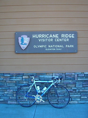
But on to the cycling. I started at the bottom visitors center, about 17 miles from the top. Didn't really warm-up, just hit the climb and made sure to stay in the little ring (39 tooth) at first - which was easy to do since it starts out at about a 6-7% grade for the first 8 km or so.
The road starts as worn chip-seal surrounded by greenery that would soon turn more sparse and more alpine.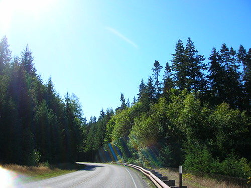
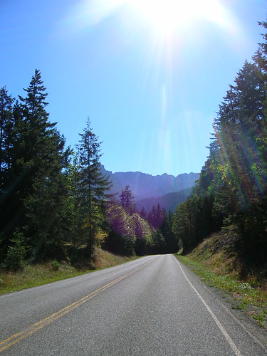
While I was keeping the pace in the Tempo zone, I was also taking a little time to take in the scenery and capture a few shots like this. It was the perfect day for a climb in short sleeves - it might be a while before I get to do this again. (Snow is expected at the top on Monday!)
In the middle or so of the climb I felt that it was time to kick it into the big ring (53 teeth) and push it. The road wasn't as steep in the middle section of the climb, and I could feel it since the pedaling was getting easier. So I kicked it up a notch. Sometimes I can hit a "sweet spot" on climbs where a 53x23 gear feels just right, and keeps me going relatively fast. Towards the end I could see my heart rate start to rise and my legs start to get sore, but I kept on truckin' for the first hour at least to see if I could set a new personal record (see Data section below).
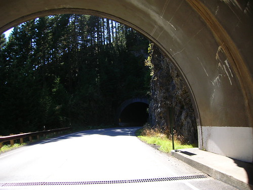
There are three small tunnels to go through, but they're short and traffic was light anyway.
I used a rear flashing light just in case.
Right as I hit the one hour mark I let up, happy to have pushed hard for an hour, and took it easy the rest of the way. Enjoying the scenery, which is easy to forget to do sometimes if you zone out staring at your front wheel.
The scale of these views/climbs can be overwhelming sometimes but that's why I love it. I love the humbling feeling of looking over a mountain vista, up at a star-filled sky, or at an ocean view and thinking about how insignificant we are. Oh and it was a great workout too.
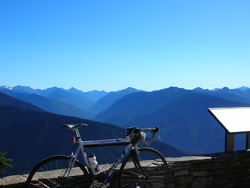
5,242 ft at the top Visitors Center at Hurricane Ridge. I bought a coffee mug as a souveneir.
Set a new peak one hour record. My previous best was back in April, 243 watts for one hour (was on a SiR winter training ride). The season of riding and racing has increased my capacity to turn the pedals harder for an hour, and this time I came out at 268 watts. Perhaps could have "scored" higher with more effort (HR average was just 156 bpm, max is 196). Anyway it's nice to see a noticeable increase in the data as a result in training.
Peak 60min (268 watts):
Duration: 1:00:00 (1:01:37)
Work: 966 kJ
TSS: 91.3 (intensity factor 0.955)
Norm Power: 272
Distance: 17.946 km
Elevation Gain: 991 m
Grade: 5.1 % (916 m)
Min Max Avg
Power: 112 565 268 watts
Heart Rate: 93 175 156 bpm
Cadence: 16 87 64 rpm
Speed: 0.4 51.6 17.9 kph
Crank Torque: 0 169.9 40.8 N-m
Data for the full ride.
Entire workout (251 watts):
Duration: 1:40:34 (1:43:32)
Work: 1514 kJ
TSS: 137.8 (intensity factor 0.907)
Norm Power: 258
Distance: 27.624 km
Elevation Gain: 1659 m
Grade: 5.4 % (1477 m)
Min Max Avg
Power: 0 565 251 watts
Heart Rate: 93 175 155 bpm
Cadence: 16 87 62 rpm
Speed: 0 51.6 16.5 kph
Crank Torque: 0 177.1 38.9 N-m
I definitely want to do this climb as part of a full ride next year! It'll be worth the slog out there.


12 comments:
Hurricane Ridge is a great ride. I've done it a few times with friends. We planned to hit it again a few weeks ago, but the road was washed out.
Thanks for the reminder to squeeze this in before winter hits.
Thanks for posting.
I sure hope the snow doesn't stay because I'm hoping to squeeze this one in before the summer really ends. Congrats on the personal best (even if I don't really understand this watts and kilojoules stuff)!
Wow! That looks great. I might have been able to do this one... Not as fast, probably, but 5-6% grade is right up my alley.
I should add, unlike the 10-15% (but short) I seemed plagued around here. Ack.
Nice. Set your FTP to 275!
Hi Matt! I'm sorry, are you planning to support http://groups.google.com/group/veloroutes group? It does not allow me to join... Are you going to work on http://veloroutes.org/bikemaps ? At least with Garmin GPS it has some problems bugs in generated files...
By the way, both I and my partner are web developers (although I didn't work with Google technologies) and might be able to help in debugging your veloroutes software. It would be so nice if less buggy. Last examples of routes which do not calculate elevations, even after 24 hours are http://veloroutes.org/bikemaps/?route=41940 and http://veloroutes.org/bikemaps/?route=41937. And again, .TCX files generated by your site tend to shut down Garmin Edge 705 GPS probably due to a bug in file format. An example of such route is http://veloroutes.org/bikemaps/?route=41075. It's a pity that such a great site application has such serious errors.
Thanks all for the comments!
Vladimir,
Sorry about the veloroutes bugs - while a lot of old ones have been fixed there are definitely some broken features.
The TCX format bug is a weird one - one I thought was fixed (the files validate against the schema last I checked), and if you can figure out what's wrong with my TCX files I'd love to hear what you think could be wrong with the files. (Training Center isn't helpful, all it says is "File Format Incorrect" or something along those lines)
Thanks for the feedback, I'll look into these issues. (Btw the elevation has been filled in for your routes)
Hi Matt! No need to be sorry: I understand, you're developing it on your own time. Thank you for your reply. Unfortunately, I'm not familiar enough with Garmin Software and TCX format. As you said, Training Center is useless in debugging this issue. I sent a message to Garmin support (they answered). I will try to send them a generated TCX file and ask to give it to Garmin software developers. But who knows if they will want to participate...
Hi Matt! Glad to tell you my partner figured it out:
Training Center do not accept TCX files with <name> tag containing more than 16 characters including end-of-string character. An attempt to copy such a file directly to Edge 705 device creates a course which immediately shuts down a device when trying to open it in a map or Edit mode. That's it!
It's hard to believe that Garmin OS is so unstable. Imagine your PC shut down when you try to read an XML file with a long tag name?
It's a shame on Garmin OS developers...
It is enough to open such a broken TCX file in a text editor and to shorten a contents of a name tag, and file becomes usable again. It would be nice if you could check / fix routes I already posted:
http://veloroutes.org/bikemaps/?route=34411
http://veloroutes.org/bikemaps/?route=35604
http://veloroutes.org/bikemaps/?route=36672
http://veloroutes.org/bikemaps/?route=39147
http://veloroutes.org/bikemaps/?route=41075
http://veloroutes.org/bikemaps/?route=41937
http://veloroutes.org/bikemaps/?route=41940
Also, would you please put a note and/or a check for a maximum name length on veloroutes.org?
Sorry for posting it here Matt; I don't have your email. Here's a response from Garmin Support, which you may find helpful (in addition to that <name> less or equal 16 character </name> rule):
Dear Vladimir Kelman,
Thank you for contacting Garmin International. If the TCX file is there but is not uploading then it likely has some corrupted lines. These can be difficult to troubleshoot and somewhat time consuming. Depending on how important these files are to you, you can attempt to recover them if you should so desire.
To do this I would recommend running them through this 3rd party website*: http://www.validome.org/xml/
This website validates xml files, and since TCX files are in XML format it can let you know where most errors are in a TCX file. In addition to this, you may want to search the Internet for something like "xml corrector". There are 3rd party programs* that are designed to do this tedious process for you.
To use this site please:
1. Select Browse and locate your file.
2. Select View Sourcecode and do not select Well-Formedness only
3. Select Validate to locate your errors.
4. Open your TCX in a text editor, such as Notepad.
5. Select a portion of the error from Validome and copy it.
6. Open up the Find box in your text editor, and paste in the small section from Validome to locate the errors.
7. Typically each file needs to have complete tags e.g. <lap> </lap>
8. For additional information on the TCX format please visit these links:
http://developer.garmin.com/schemas/tcx/v1/
http://developer.garmin.com/schemas/tcx/v2/
I was able to use www.gpsies.com* to convert the non-working tcx file to a tcx course file that imports into Garmin Training Center, and if used on the unit will not crash it. I would pass this information on to the individual or utilize it yourself.
Thanks, Vladimir!
Your detective work has solved this strange issue. I had previously posted to the Garmin developer forum but got no response, I never thought of tech support.. and I wrote an XML validator in C#, that seemed to show the files were OK.
I also fixed an issue with the total distance in the TCX file, it was off by quite a bit. The files I tested import into Training Center now, please let me know if the files work on your unit as well.
Thanks!!
PS my email is [veloroutes at gmail]
Post a Comment