(Sorry in advance for the horrible formatting going on here - the blogger interface really sucks sometimes!)
Yesterday I ventured out for a ~155 mi/260 km ride at 5 AM. The goal? To ride to a 70-mile ride from Granite Falls to Barlow Pass, near Monte Cristo, and back. The Cascade ride started at 9 AM in Granite Falls, and there was a ribbon-cutting ceremony at noon at the top of the pass. Nothing like little deadlines to keep you on pace! 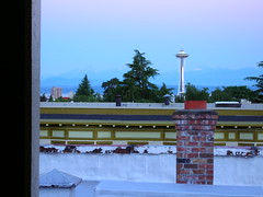
On the right you can see what it looked like when I rolled out at 5 AM - a mostly-sleeping town. I love it when the roads are empty like they are on Saturday morning.
So why not turn this into a big out-n-back adventure I figured?! I calculated out about 155 miles, or 260 km of fun in the sun. 150 km of that would be solo, the rest riding with people on and off. I figured I'd be back somewhere between 5 and 7 PM, depending on lots of obvious factors.
Elevation profile of the first/last part of the ride - Seattle to Granite Falls (45 mi/72 km) - I didn't realize it in the morning, but coming back (this profile from right to left) was way tougher than I thought it would be!

Elevation profile from Granite Falls to Barlow Pass - the first part had some tough grades you can't really see in this graph. After that I could hold 30-34 km/h (18-21 mph) just about the whole way!

I followed this route, out and back:

The ride to Granite Falls
Getting on Lake City Way at about 5:30 AM, I find the road more or less to myself! It seems mostly downhill heading north, and I can take the whole lane. The sun is just rising at this point, and I know it's gonna be a hot day, so I enjoy the shade while I can.
Turning off of Lake City onto 80th Ave, the hills start. Not "rolling" hills, just plain hills. I saw a few markings from the "Summits of Bothell" ride on this road, and noticed that they actually go around the hardest parts! (Where 80th meets 228th). Least it looked that way.
Then it was a right on 228th for a blasting downhill, followed by a steep climb of 200-300 feet or so. Before too long I took the left on Highway 9 and settled in for some light highway riding.
Some parts of Highway 9 are sketchy, but for the most part the shoulder is there and decent.
And this early in the morning, not much traffic either (~7 AM). Passed Snohomish feeling hungry, but pushed on for a warm breakfast in Granite Falls before the ride.
Eventually I hit highway 92 and took a right that would take me into Granite Falls. Still a little hungry, but my water and energy bar nibbles are enough to get me by. That and the clear views of the Cascades were enough to keep on truckin'.
The Mountain Loop Ride
I made it to Granite Falls at about 8 AM - an hour early! So I rode around the small streets and looked for the High School where the ride started. I knew the route anyway, but was supposed to meet up with friends. I went to McDonald's and had a monstrosity of a breakfast meal, and chatted a bit with the locals. They were genuinely enthused about the ride, and asked all about it!
At 9 AM I rolled out on Alder Dr/Mountain Loop Highway, latching on to a group of 4-5 riders who I thought were at the front of the group at the time. I never did find the start point of the ride, but since I knew the route it didn't really matter. Hadn't seen the peeps I was supposed to meet by this point, but I figured I'd run into them eventually.
I hung on with some RAMROD/racer types, and eventually dropped them on the first big/steep climb. Mind you I wasn't racing them per se, just pushing myself as hard as I could. I was passing, and passing, and passing people on this climb, and eventually there was nobody else to pass!
Not sure if that meant I was ahead of everyone or not, but in Verlot I decided to stop and wait for Racheal/John/Andy to show up. After 25 minutes of watching everyone that I'd just passed pass me, I set off again.
The
route was just to follow Mountain Loop Highway for 30 miles up to Barlow Pass. From Granite Falls to Verlot there were some tough/steep hills to conquer, but after that it basically flattened out to a 2-3% grade. I held 32 km/h (20 mph) for almost an hour going up it! Needless to say, I felt strong.
Barlow Pass
I got to the top of the ride at the end of the paved road, Barlow Pass, at about 11:05 AM - 6 hours into the ride, half way. I waited around for John, Rachael, and Andy to show up, and eventually decided to take the Ciocc off-road and check out Monte Cristo! 4 miles of unpaved road on 23's - a challenge to say the least. The tire tracks were mostly packed dirt, so it was doable.
That is until I ran into this - a freshly-plowed path through an avalanche!
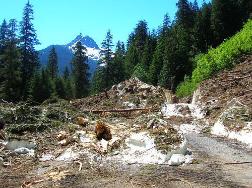
Yup, that's snow mixed with debris. A view from inside the wreckage:
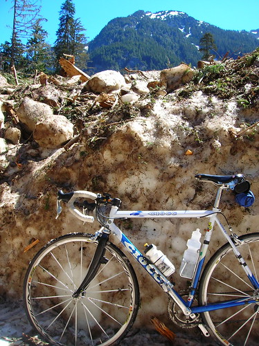
It was tough walking my bike through the packed debris, and after 100 feet of walking I turned around, since I couldn't tell where the snow trail ended.. Oh well, I'll have to visit Monte Cristo another day. There were other people walking back there, but I didn't feel like slippin' and slidin' my way out there with the velo in tow.
So I turned around after getting some photos, and went back to the pass where the ribbon-cutting ceremony was. Rachael showed up eventually, and not too much later John & Andy did too. After resting for a while and chatting, when we were ready to go the ceremony had begun, and we were trapped behind it!
The 1/2-hour ceremony slogged on, and eventually we were free to enjoy the downhill. We rolled down at about 1 PM, and it took us ~2 hours to get down - about the same as it took me to get up! We took our time and enjoyed the sun and scenery.
We arrived back in Granite Falls at about 3 PM, and my trio of riding buddies split off to find the car to head home. Me? Time to ride back! Sure the offer of a ride back to Seattle sounded nice, but I wanted to take full advantage of the nice weather we finally have. And take advantage of the fact that all of my previous rides make doing long-distance like this much easier than it should be!
The Ride HomeThe route back was tougher it seemed - the hills seemed steeper, the sun hotter, and my body much more tired than it was before. I wasn't anywhere close to bonking, just feeling the grind of a long day. And sun-burned!
Heading west on 92 back towards Highway 9, the sun was just beating down with no remorse. I applied sun-block 5 or 6 times throughout the day, and still got burned! Highway 9 was even worse, with one 5 km climb that was mostly in the sun - I have to admit that my wool SiR jersey was maybe a little bit thick for that weather, but all I could do was plow on!
Traffic was really heavy on Highway 9 heading south at ~4-5 PM, but the shoulders were accomodating. This was the part where having someone to ride with would have helped - keeping a decent pace (25 km/h average was the goal, which I met) by yourself hour after hour is hard!
Finally I reached the turn for 228th, but knew what was coming my way - two big climbs to get me over to 80th Ave. This section took way long, and I was heading directly into the sun it felt. No shade to be found.
228th St (Ave?) looking west - the uphill section in the distance was even tougher than it looks, especially in 90-degree heat! This was about 140 miles into the ride too: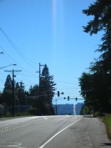
The last little kick of 228th before 80th was brutal - I'm gonna throw out a number and say that it was an 18% grade, if only for one block. But damn, in the sun, and with the distance, it was a real tough one. Did I prevail? You bet. (Btw now I see why the Summits of Bothell ride skips that last little section!)
I skipped Lake City Way on the way back, as it was now 5 PM or so and not the time to take that road on a bicycle! I got on the Burke-Gilman trail and then got sick of it due to too many people on it. So I opted to take the "hilly" way home, e.g. Perkins/180th to 5th Ave back to Seattle. You can get off of the B-G trail and take this at the intersection with the Starbucks.
Finally I found some shade coming up through Lake Forest Park, and took the three-mile climb at an easy pace. Heading south on 5th Ave (parallel to I-5), there were three more hills to climb - but once I was over the last one (just after Northgate) I knew most of the climbing for the day was done.
Taking Harvard/10th Ave up Capitol Hill wasn't easy at the end of a 150+ mile ride, but I did it! And I even sprinted onto Broadway at the end, just to prove to myself that I could do it. And I did it, rolling back home at 7:30 PM.
Many more photos here: http://www.flickr.com/photos/98486054@N00/sets/72157605902296002/
Total Distance: 260 km/161 mi
Overall Time: 14.5 hours (incidentally what the StP took last year!)
Rolling Average: 25 km/h (15 mph) - I was really happy with this


