Monday, July 28, 2008

Critical Mass In The News Again... For All The Wrong Reasons

It's a shame that you don't hear about the 11 months out of the year that Critical Mass pulls off their fun protest rides without incident. Like most news I suppose, you only get to hear about when things go south.

No need to link to all the news outlets' stories, surely you've seen them already. Perhaps I can shed some different light on the subject, with an eye-witness account from someone we'll call "B":

What I witnessed Friday on Aloha was (imo) terrifying. Drivers will sometimes get angry when they're being corked, but this guy ended up getting rather violent. My story (I feel obligated to share since the news really screwed this one up) is as follows:

Some of us were riding by as this guy in his Subaru decided he wanted to merge into bicycle traffic. Coming close to hitting us, a few cyclists asked the driver to wait, and the driver got angry and yelled that he had a reservation and didn't want to wait for the cyclists to finish passing. Conversation got a little heated and immature, and I didn't feel like participating in that, but I wanted to make sure everybody was safe in the end, so I stuck around on the sidewalk waiting for everything to settle down and the guy in the Subaru to leave. After the driver backing up really quickly out-of-the-blue, the cyclists expressed more concern about safety and about 1 minute after that, he decided to gun his car towards the cyclists. The cracking, crunching and screaming was unreal. The driver didn't just nudge or try to bend bikes in front of him as sometimes drivers do..he rammed into a group of human beings with obvious disregard for their safety. One guy got his leg ran over, another girl got her ankle hurt(broken?), and another guy was forced onto the hood, then roof of his car from the impact. The driver then sped off down the street (going between 30 and 35) with a cyclist hanging on to the roof rack for dear life for a block or so. Concerned for the safety of the man on the roof-rack, and the others on the road, I decided to run after the car to make sure I could help the guy if he fell off the car. A few others were running behind me and we were able to catch up to the car. One person used a knife to slash the left-rear tire and it was obvious he did this to try and prevent the driver from running any further and not to be malicious or thuggish. One guy with a u-lock smashed a hole into the rear window and started banging on the car. More cyclists began to rush the car as the driver made a choice to get out and appoligize. The same guy that smashed the rear window (some not-so-smart thug) came between me and the driver and whacked him in the head with a kryptonite U-lock and the drivers' head started bleeding. After that I ran around to make sure everybody was OK and waited until the police showed up.

In the end, I am happy that most (except the person with the u-lock and others that may have nagged the driver) of the cyclists were helpful and non-violent. I'm just disappointed that the news made the driver look like a victim...amazing. Anyways, maybe it was the thug with the u-lock that gave reason for them to skew the story, but still... they should get their story straight imo.


Surely both sides took things a little too far, but what I can't stand is how the media (and apparently the cops) jumped on the drivers side right away. I don't condone hitting anyone in the head with a U-Lock, violence is lame 100% of the time. But a car can be used as a deadly weapon, and in this case it seems like that's exactly what happened.

I think both the driver, and the U-Lock attacker, should be charged with assault. The driver apparently hopes that nobody is charged, and I'm sure that includes himself.

One thing that few CM-outsiders seem to grasp is that Critical Mass is a form of Civil Disobedience. And as with most forms of protest, the point isn't just to piss people off, but the point is to make a point. And "the point" here is that, as the CM motto goes, "We aren't blocking traffic, we ARE traffic!"

So when I ride with CM, I'm not thinking "this will change the minds of all those drivers." I'm thinking, "Every damn day is Car Day, why can't one day (really just a few hours) out of each month be Bike Day?"

And please don't give me that "but it makes us look bad" crap - drivers have been mowing down cyclists, etc, probably since the first Model T's rolled off the lots. If CM went away tomorrow, you'd still be left with a bunch of drivers who "didn't see you, sorry."

Anyway, I'm going to make a point to go to CM next month, and see how it goes. And if something goes south, again, I'll be able to write up my own eye-witness account of it. And take pictures. Long live Critical Mass!

Saturday, July 26, 2008

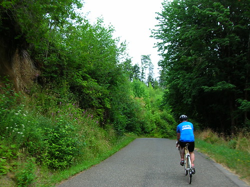
Tahyua Hills 200k Brevet 2008: Up. Down. Up. Up. Down. Repeat.

After getting a DNQ result in my last 200k, I was dead-set on finishing this one with credit. No speed/time goal in mind, besides doing the ride at something above the randonneurs' minimum of ~9 mph, or 15 km/h.


This route is known for its inclines, and in a similar fashion to the Olympic Peninsula, and the Puget Sound islands (Vashon, Bainbridge, etc) lots of hills is what you get. Not huge, maybe 400 feet at most, but some were quite steep. And as you can see from the elevation profile, there were lots of them!

You can find the map of the route here: [map]

Check out the elevation profile of the route here: [elevation/map]

I heard quotes of 8-9 thousand feet of climbing for this 209km/130 mile brevet. A good warmup for the RAMROD (coming up on Thursday)!

The Ride to the Ride

I made it there with time to spare, as the Ciocc is pretty good at carrying me at ~36-40 km/h (23-25 mph) on the flats, but on the hills it's mostly up to me, and going up Delridge on the way to the ferry dock at 5:30 AM, I took it easy.

The sun was still rising, the air cool. But my wool jersey, and the effort, was plenty to keep me warm.

On the right you can see what Seattle looked like (well, minus the slight blur) from under the Viaduct.


Riders queueing up for the ferry to Southworth:
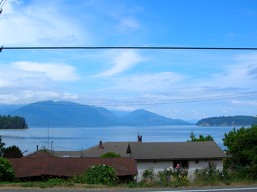
From the ferry, you could see Mt. Rainier:

Southworth to 1st Control

Riders getting ready to roll:

After the pack rolled out at 7:00 AM sharp, the usual filtering of the riders took place. The first 10-20 km were true rolling hills (you could keep your speed over the top of most of them), and Chris, Joby, Robert, and I stayed together, but after a while Joby & I ended up riding with two other riders, at the front of the pack.

I really wasn't planning on trying to do this brevet fast, but the itch was there and I scratched it! My speedometer wasn't working, but I'd guess we cruised at about 40 km/h for a while, the three of us trailing behind a really fast guy on a Litespeed.

But I knew I couldn't hold this pace forever, and planned on taking it easy after the first control. We made it to the gas station at about 8:20 AM or so, 40 km into the ride. The really fast guy spent about four minutes there, and then rolled out. I bet he finished first!

At the first control:

Joby & I bought some water, snacks, etc, and shortly Chris rolled up, followed by Robert. We rolled out together, probably 20-25 minutes after arriving. Probably too long to spend at the first control in a ride, but for this one I wanted to stick with the trio.

To The Next Control

Light rain started coming down, and after a quick stop to put on rain jackets, I was donning my brand-new Rapha "softshell" jacket - glad to put this thing to use, considering I spent lots of dough on it! It worked perfectly, and fits way better than my old jacket; this one doesn't flap in the wind, which I always hated about the old one.

After about 10 minutes of rain, it stopped as quickly as it started. Luckily the jacket is breathable enough that I didn't need to take it off! Another advantage over my old Shower's Pass jacket.

During the next stretch we ended up pacing behind a fast tandem, and tacked on to their paceline. Again I have no idea of our speed, but it was definitely a decent one! None of the climbs were too bad at this point, and after a while the paceline seemed to slow down, so I broke out of it and went up the road.

I knew we were close to the next control so it wouldn't be long before the paceline would catch up eventually. Rode alone for the next few kilometers, and made it to the next control at Kay's(?) Corner, a gravel patch overtaken with a tent, volunteers, and lots of bikes!

The famous SiR support was there, making sandwiches, offering water, mechanical service, the works! Thanks a mil' to everyone who helped out with the ride. Shortly after I got there the tandem's paceline showed up, perfect. Back with the trio.

I spent another 20-25 minutes here at least, eating chips, the falafel wrap I'd brought, chatting, and downing liquids. The word was that the next section was where the hills really were. As Mr. Burns from The Simpsons says, "Excellent."

The Real Hills Begin

500 meters or so after the control, we started going up. And up. And up. And down. Then back up. We caught up to a bunch of riders that had left the control before us, many of them we'd see throughout tbe day.

The roads in this section (Kitsap Nat'l Forest?) were great! Pretty narrow, no center line, but no traffic either. Surrounded by trees, trees, trees. We saw a small deer too!

A pic of Chris rolling through said tiny road:

We started pacelining again, I think with the same tandem from before. Somewhere along this section I went off again on my own, passing lots of people. It wasn't that I didn't like riding with everyone I was with, it was that my legs said, "we've got the energy, lets see how far you can go fast(er) for?" OK, let's do it.

So I rode alone for a few kilometers, then one guy that I'd passed caught up and passed me on a climb. It was so easy to "give up" on some of these climbs, and switch down to 39x25 (my lowest gear) and soft-pedal up the incline. I passed him on a big downhill somewhere along the way, and after the right on to Seabeck-Holly(?) Road, more big climbing started. In fact I think we went uphill for about six kilometers or so, but without a cyclocomputer it was hard to be sure. It started steep, and got less so as it went on. But it went on for a while!

Rode alone for the remainder of this portion until the next control.

The Dog

Near the top of the hill, or what seemed like it was about to the be the top, a medium-sized brown dog came sprinting at me, dragging a red leash (rope?) behind it. I guess all the cyclists passing by was too much for it to resist! It came at me from the left, and I was too stunned to do anything but keep on pedaling, hoping that my pace was great than its. It really wanted a piece of my calf, I could just tell.

But in the end I just rode away from it, I'm really glad the scare worked out for me. I heard later that it didn't work out for someone else, and they had their ankle nipped, but nothing too serious.

Seabeck

I was expecting at least an intersection, a stoplight, something to denote a "town" called Seabeck, the next control. But I think Seabeck is really a codename for about four shops (general, massage, pizza, gifts, espresso) that line the waterfront. About 10 riders were already here, enjoying water, ice cream, chips, the good stuff (there was probably someone hiding in the portapotty, snorting some kind of secret Hammer powder, shunning any solid food).

I bought peanuts, Lay's chips, water, and an "Arizona" Green Tea, those drinks are so good. For this ride I'd decided to stay away from sugary things like I used to eat on rides, like Snickers/Payday bars, Cokes, etc. Trying to focus on salty things, at least when it comes to food. And I can say that it worked! No upset stomach, the first time in a while on a long ride.

Before too long Chris showed up, and Joby & Robert weren't too far behind. We sat at a picnic table outside the store and enjoyed being off the bikes, stuffing our faces with something or other.

I spent at least 40 (yes 40!) minutes here, but at this point we had plenty of time in the bank, as 13.5 hours are given to riders to complete this 200k. So there was no rush, no pressure, just a nice day for a great ride with some hardcore cyclists.

Anderson Hill Road, and More Hills

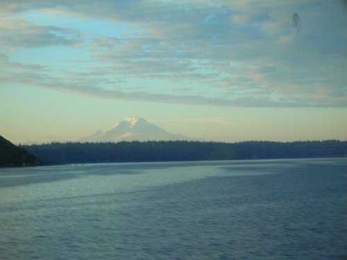
The scenic lead-up to Anderson Hill:

The next big ascent was apparently Anderson Hill Road, which everyone said was the worst climb of them all. We rolled over some scenic roads (above) and finally made the left turn that brought us to our next big one.

This hill felt like 7-10% grade, and went for a km or two. The worst part was the sun beating down on you, with no wind or breeze to cool the skin. That and the fact that my 39x25 wasn't really an easy gear on this hill!

We finally got to the top and stopped for a mini-break on the side of the road. Somewhere along this portion Robert fell behind the three of us, and we never actually saw him again. This section featured some decently long climbs, but nothing steep. We passed a "high-powered rifle" shooting range, which sounded, of course, really loud with each gun clap. I pictured the occupant in the house across the street cringing with each shot, but hopefully they're OK with it! I was glad to be gone from there.

This road seemed to go on forever and ever, and went slightly up as well. Somewhere along the way I swear I saw a motorcyclist shake his head in disgust at me/us, and this was probably the case given what happened to Chris about 30 minutes later: At the intersection just before the next control, we were stopped waiting for the green light. About 30 motorcycles were taking a right, passing us going the other way. Apparently one of them looked Chris in the eye, and then spit a sunflower seed at him! That's a new one.

Brevet riders at the last control before the finish - after this, "just" ~30 miles to go!

After surviving some stretches as long as 10km on Highway 3, and a little bit on Highway 16, and even doing a "victory lap" at the roundabout because we missed the correct turn, we finally made it to much nicer roads. Meaning, they were two lanes with less than 10 cars/second passing you by.

I was definitely tired by this point of the ride, but not done. Although close. Had this been more than a 200k I would have taken a long break, but we trudged on.

Climbing "One Mile Hill" I believe - this was taken over the shoulder, while moving:

On the approach to the ferry - now those are rolling hills! Looks even cooler in real life:

I'm cutting out a lot of the rest of the ride, and possibly other tidbits worth mentioning, for the sake of brevity. For instance we passed through Silverdale during their "Whaling Days" festival, which meant parking on the shoulder, and lots of pedestrians crossing the road. And lots of bass coming out of cars/trucks for some reason. But maybe that's always the case out there?

At 5:30 PM or so we rolled into the finish, happy to be done! We and had to wait for about an hour and a half for the next ferry - but luckily the corner store had decent sandwiches (fresh as of two days ago), and soda w/ ice - mmm.

We told war stories from the road, and pondered what happened to Robert. Hope you made it! Sorry we didn't wait for you, I kind of feel bad about that...

Ride Stats
Distance: 209 km + 23 km commute to the ferry = 232 km or 144 miles.
Ride start time: 5 AM
200k time: 7 AM to 5:30 PM or 10.5 hours (for reference the fastest was probably closer to 7 hours!)

Official times will be posted here. A few more photos here.

Monday, July 21, 2008

Beyond Ramrod: The September 600k Brevet

There's been rumblings of a Jan Heine 600k brevet. If you don't know Jan or his riding, let's just say he's known to push the limits!

So the details have finally started coming in, and it looks like he's taken the RAMROD route and added a bunch of big climbs to it.

Below is a map (done by me) of what the route will be, more or less. Click here for the actual map.


The text of Jan's description from e-mail pasted below:

For the Fall 600 km brevet, we were asked to provide a fitting finale to a season that carried the motto "Return to the Mountains". SIR riders have come a long way in recent years - when the course of this year's Spring 600 was first used, the DNF rate was high. This year, almost everybody made it. With SIR riders (and visitors) riding so strong, we decided to provide a course that will challenge all riders.

The route combines a lot of favorite roads. It is very scenic - you get to visit Mount Rainier several times, and you'll ride into the blast zone of Mt. St. Helens. You could call it "Ramrod++", and there is no lottery to get in! Here is the preliminary route:

0. Start in Enumclaw.
1. Follow Ramrod route to Eatonville, Elbe, Mt. Rainier.
2. Climb to Paradise
3. Descend to Ohanapecosh (with Backbone Ridge as a "bonus" climb)
4. Ride to Packwood and on to Randle
5. Climb up to Windy Ridge (we may cut the last few miles past Independence Pass, which feature giant rollers)
6. Turn around, return to Randle, Packwood
7. Climb White Pass
8. Overnight at Rimrock Lake (as in Spring 600)
9. Descend toward Yakima
10. Climb Chinook Pass
11. Descend to Cayuse Pass
12. Descend toward Enumclaw
13. Climb up to Sunrise Point
14. Turn around, ride to Enumclaw

2, 5, 7, 10 and 13 are major climbs.

The final course will be determined after we have ridden the route. We may cut the Sunrise portion, even though riders riding through the night will reach Sunrise around sunrise, with a spectacular view of Mt. Rainier. This also would be the first time an SIR brevet goes over 6000 ft in elevation. (For out-of-towners, consider we start at sea level.) If we cut this portion, we may instead go all the way to Windy Ridge, and perhaps add a little jog in the apple orchards towards Yakima to make up the distance.

It will be a challenging ride, but we feel it's doable for experienced randonneurs. All the roads are paved and in decent shape. Even though there are quite a few climbs (and long ones at that), none are ultra-steep. Navigation will be easy, although we plan to use some sideroads between Packwood and Randle to get off the highway. It will be a lot of fun!

Jan and Ryan

In order to get my Super Randonneur award for this year, I'll need to do this, considering my DNF on the last 600.. well they're really gonna make me work for this SR thing I guess! But like Jan said, it will be a lot of fun. (That's fun in the randonneur sense of the word, not common-usage mind you).

Sunday, July 13, 2008

STP 2008 - Seattle to Portland Before The Sun Goes Down

326 km (203 mi) done! So it's not a 400k brevet over mountains, but it was still a challenge. And lots of fun. Great weather, good scenery, and mostly good roads - the 2008 STP.


Here I am finishing in Portland at 5:44 PM, very glad to be out of the sun, and done.

I'd flatted just outside Kelso, and the old tube wouldn't fit anywhere else, so I threw it over my shoulder. 
You know, like how they did in the old days:

My Approach to the STP

I had a goal to finish the ride at least faster than how long it took last year, which was 14.5 hours (7:30 PM) finish time.

I didn't really plan on going faster per se, just getting off the bike less. This ride is so organized that there are plentiful rest stop every 20 miles or so. You could bring no money and probably get by on this ride! In fact since (most) riders pay $80+ to do this ride, that's what you're supposed to do.

But now that I've been getting into the rando scene, the prospect of treating this like a 300k brevet was what I had in mind. Meaning, I would skip just about all of the official rest stops, try to minimize off-bike time, etc. I thought I could do it with stopping only three times, which was a little too bold - but I ended up only stopping about five times during the ride:
  • 100 km: Roy, bought water w/ ice, gatorade, cinnamon roll, peanuts at a gas station (~10 minutes)
  • 159 km: Centralia, half way - ate free ice cream, PB&J sandwich, and an orange slice. Only spent about four minutes here (last year was more like an hour at the half-way point). This rest stop was crowded with other riders, in the usual mayhem of strangers that is the STP.
  • 168 km: Chehalis, more water w/ ice, chips, peanuts, jerky/cheese combo pack
  • 230 km: Lexington area, stopped at a gas station, enjoyed some more ice & shade
  • 299 km: Scappoose, bought water, mountain dew w/ ice. Sat in the shade for a few minutes.
The Ride

I left the house at about 4:25, and since I did a last-minute seat position change on the road, I knew I wasn't gonna make the official start at Husky Stadium - so I just followed Roanoke down to where the route goes, cutting off maybe two miles of the route. At about 5 AM I joined the riders, passing just about everyone I saw at 35-40 km/h (23-25 mph) - yeah, too fast for a reasonable start to a double century!

At about Seward Park a mini-peloton of about 10-15 riders caught up with me doing 40+ km/h - and thought I didn't hop onto the paceline right away, I ended up catching up to them and following a wheel or two for a while. The group ended up being split on Rainier Ave, and all of a sudden just four of us were left.

Eventually a guy in a full Garmin-Chipotle team kit (complete with crash-scars!) caught up to us, as did a few other random riders. While my plan was to avoid big pacelines altogether and do this ride more or less solo, the opportunity to cover so much ground at once just couldn't be passed up!

The Hill

At "the hill," a 300-foot climb that isn't all that bad, our average was just above 32 km/h or 20 mph! I've never averaged 20 for more than a half-mile, so this was a real surprise! But I knew my body couldn't push it like this forever, and I took it pretty easy on "the hill" in Puyallup.

Our little group split up pretty well at that point, and I never saw the Chipotle guy again. At the top I kept it solo for the most part, and just ignored pacelines that shot past.

I skipped the big rest stop at about 50 miles, and I'm pretty sure the guys that were ahead of me stopped at it. I kept on pedaling, skipping the crowded parking lot and long lines, in favor for pushing another 10 miles for topping off a 100k (62 mi) and getting supplies at a convenience store. The fast paceline I'd ridden with earlier passed me here, but I let them go. I'd decided that from this point on I was on a solo ride, more or less.

So for the next 10 miles I kept a pace of only 25-28 km/h (15-17 mph), and was mostly being passed. But I'd end up seeing just about all of those jerseys again, and even though many pacelines came by at their 40-45 km/h pace, I held off and just rode on.

Mostly because I didn't want to ride above a comfortable pace, and blow it too early. Or maybe I'd already done that.. But not stopping all that much meant that even thought many other riders rode faster than me, I kept seeing them again, and again.

Centralia - Half Way

Only stayed here for about 5 minutes, compared to the hour or so we spent here last year. Rolled out with a guy on a Ramboullet, who also rides with SIR! It's a small world I guess.

The Rest of the Ride

In between Chehalis and Winlock, I ran into a guy in a red jersey that I'd ridden with briefly on the Barlow Pass ride a few weeks ago. While riding with him, I saw a small black bug flying towards me, and it came straight for my neck! It must've been a bee, because the damn thing got stuck in the front of my collar, and stung the shit out of me! The pain wore off after a few minutes, but I'd forgotten how much those things hurt. Luckily I'm not allergic..

Just before Kelo/Longview, I was thinking to myself about how I'd flatted at a particular corner last year, and was glad not to have flatted yet.. So guess what happens about a minute later? Yup, flatted. No big deal, but I did find out that I was riding on an already-patched tube, and that my spare tube had a short stem on it, which my semi-aero Ksyriums don't work well with. Should've checked that before I left the house I guess..

I spent at least 20 minutes fixing this flat, far too long for a simple tube change, but with the short stem on the tube, it was a challenge pumping it up correctly. While I was fiddling with it the original fast paceline I'd ridden with 100 miles earlier, now with 10 more riders in it, passed me! I even heard one of them remark, "Hey there's that one guy."

It was the classic tortoise & hare scenario, but this flat ruined any chances of finishing before them. Not that it matters, but it makes for good pacing!

With the flat fixed, I rode on to Longview, and was really happy to hit the Lewis & Clark bridge, which meant about 80 km (50 mi) to go. I, for some reason, sprinted up the bridge, passing a bunch of people. Guess I was in my favorite riding terrain: tilted.

After the bridge I stopped for more water/ice, and bought some food I never ate. I hadn't really had a real meal by this point, and my stomach was protesting for sure. Left the store just behind a rider with a McDonald's team kit on - looked like a racer. Let him ride away though, I didn't want to do someone else's pace. But I figured I'd see him again.

The Last 50 Miles

The last stretch of the STP (Highway 30) is strip-mall hell, with five lanes of traffic. But at least at this point you know you're close to the end! I stopped in Scappoose for more supplies, and spent a while recovering from the sun here. Talked a bit with a local rider, who was asking about the STP. I didn't say anything, but at that point my stomach was turning, and I felt kind of queezy. But I answered all the questions, and enjoyed some ice water. "Laugh on the battlefield, cry in the dojo," I think is how the old saying goes.

The last 30km were slow but steady, and I saw quite a few familar jerseys (people that had passed me earlier in the day) go by. But I was ready to be done, for sure! Had this been a 400k I certainly would have had to stop for real food, but I plowed on.

Coming into Portland I saw the familiar sites like that bridge you cross to get into Downtown. While I felt slightly ill, I looked at the time and knew that I'd met my goal for this ride, and had cut off 1.5 hours from last year's time!

Thanks to all the riders I rode with, all the support staff, and Cascade too - I'll be out next year, with a goal of cutting off even more time! 

Timeline
Left Seattle at 4:45 AM
Arrived in Roy, WA at 8:05 AM
Centralia College at 10:15 AM (100 miles, 161km, roughly halfway)
Scappose at ~4 PM
Finish in Portland at 5:44 PM

STP Ride Stats

Distance: 323 km, 201 mi
Time: 13 hours overall
Average Rolling Speed: 28.6 km/h (17.7 mph) (This was 31 km/h at the halfway point, and 30 mk/h at 150 miles - those last 50 were much slower than the rest, for sure)
Flats: 1
Rest stops skipped: 15
Snakes seen: 1

Monday, July 7, 2008

Ultimate Island Explorer: 2,000km Brevet!!

While I'm gearing up for STP & RAMROD this month, others are looking beyond. Waaay beyond "puny" double-centuries. Beyond the PBP & Cascade 1200 even!

Mark Thomas forwarded this to the SiR mailing list - word of a two-thousand kilometer brevet, put on by a Canadian power-house of a cyclist! Ken Bonner recently did the Cascade 1200 in a blazing 64 hours!

Pasted e-mail:

"Longer than any RAAM Qualifier, tougher than most double or triple centuries! The Ultimate Island Explorer (UIE) 2000k brevet organized by Ken Bonner on behalf of the British Columbia Randonneurs Cycling Club is a scenic (lakes, mountains, rivers, forests; seaside and tourist towns) and challenging cycling experience for the tough elite cycling racer, triathlete or 1000+ km experienced rando-cyclist. 65,000 feet of climbing with only 4 climbs that are in the 1000ft/300m -1400ft/425m elevation range – the rest of the route is what is euphemistically called ‘undulating’ J

Temperatures are moderate with normal day time highs up to 85F/29C and night time lows down to 50F/10C. Although a sunny time of the year, rain showers can be expected. Wildlife sighting of black/brown bears and deer are common (lots of deer at dawn and dusk in suburban Victoria).

The entire route is on Vancouver Island, British Columbia, land of the totem and Coast Salish nation (North American Aboriginal Games take place during the week of August 3), outdoor recreation and Canadian National elite sports training centre.

The UIE 2000 takes place on paved roads, some with a low traffic count, and some with considerable tourist traffic. It also includes territory followed by other Vancouver Island brevets, such as the Tsunami 300; Highway to Hell 400; Backroad 400; Northward Ho! 600; Tofino 600; Hare & Tortoise 1000 and VanIsle 1200.

True to its randonneur roots, this longish brevet has little support. The first 350k is an out and back from the capital city of Victoria which permits riders to use their motels for support at the end of the day. For a separate bag-drop fee of CAN$190, participants’ can have adrop-bag transported to/from each of two control hotels -- each of the control hotels will be accessible 3 times. For the 1st hotel (Quality Inn) in Parksville access is at 670k; 1025k and 1825k; for the 2nd hotel (Coast Discovery Inn) inCampbell River access is at 1140k; 1325k; and 1720k. A small number of rooms are being held at the Quality Inn at the rate of CAN$109/day plus taxes; and at the Coast Discovery Inn at the rate of CAN$110/day plus taxes.

Personal Support Teams: As per normal randonneur rides, personal support is only permitted at control locations.

Safety: Bicycle in excellent condition; B.C. traffic law requires bright lights attached to the bike front and back and an approved cycling helmet; highly recommended are extra back-up lights; reflective vests/sash, wrist and ankle bands; large reflective triangle. Look like a moving Christmas Tree!!! J

Fees: Mandatory membership in the BC Randonneurs Cycling Club -- CAN$20; Brevet Fee – CAN$15; Drop-bag fee – CAN$190. Total = CAN$225

Start/Finish is in Victoria, British Columbia. There are direct flights to Victoria International Airport from San Francisco and other North American cities; also Victoria is a short flight from Vancouver International Airport or a scenic 1 ½ hour ferry ride across the Strait of Georgia.

The Hydrofoil passenger ferry from Seattle will also transport a limited number of passengers’ bicycles.

If you plan to participate, or have questions, please contact Ken Bonner by email -- see BC Randonneur Vancouver Island Schedule for email address http://www.randonneurs.bc.ca/schedule/sch_vi.html

I look forward to seeing you on the ride!

Ken Bonner"

Once again this just goes to show that it's all relative! I might pencil this in for the 2010 season, assuming I live through a Cascade 1200!

Saturday, July 5, 2008

July 4th Spin To Snoqualmie Falls, Cougar Mountain

Yesterday I set off with a loose route in mind: Renton, Issaquah, Cougar Mountain, maybe Snoqualmie Falls. I figured it would be about 70 or 80 miles, and if it turned out to be 100, well that would've been OK too!


With the STP next weekend, and the RAMROD a few weeks after that, I wanted to combine distance with climbing - then again, it's hard not to do that around here.

Check out the elevation graph for this route - sort of like a roller coaster: (max elevation is 1,000 ft or ~330 m)
Starting out, I did the familiar Lake Wa Blvd heading south at 1:30 P.M. to the tune of a light headwind. But a headwind I could hold 32 km/h into it. By the time I hit Renton, I was
 averaging 29 km/h - a good start, but I knew the speed wouldn't last.

In Renton I believe 99% of cyclists take one look at the four-lane Highway 900 that heads uphill and think, "I'd never go up there." They're doing the Lake Wa Loop - a great route - but I never, ever, ever see anyone else riding up this hill! Come on folks, it ain't so bad.. (although the shoulder is kind of dirty, covered with rocks & debris)

Highway 900's hill is only 100 meters high, nothing special. But the descent through the thick country woods is well worth the slog through strip-mall-hell! Soon enough you're in the country, enjoying clean-ish air and stunning views.

After getting up and over the Plateau, I took Issaquah-Fall City road east, towards Fall City. After a fast downhill (didn't even touch the brakes!), I took a right and followed Issquah-Fall City Rd for a few more kilos until I hit Fall City. Here's what the stretch before Fall City looks like, awesome:

After spending a little time on Highway 202, I was at Snoqualmie Falls at about 4:39 PM. It was crowded, but there was enough space for me to squeeze in and see the Falls - wow.

I was somewhat dreading the way back, with a little climb up Iss-Fall City Road that was undulating but lasts 5 or 6 km (I think). It wasn't as bad as I thought, although doing Cougar Mountain after about 65 miles was taxing! But I knocked it out in about 25 minutes of ascension.

I tried a new descent coming down it, this time just going straight at the top and following the road all the way down to the stop sign, where I took a right. You go uphill for a few hundred meters, but then it was a BIG downhill - with a signed that warned of a 10% grade up ahead. (Lakemont Blvd?)

I hit 78 km/h (~49 mph) going down that stretch, and was pedaling so fast that my 53x11 wasn't big enough (or rather my RPMs weren't high enough). Damn I love going fast! It's a nice gradual turn at the end, compared to the tight turns going down 54th St/The Zoo climb.

Then it was a slog back up Newport Way all the way from Eastgate, and then the I-90 bike trail, across Mercer Island, and back home via 12th Ave.

Felt strong coming back up Capitol Hill - I definitely feel confident about the upcoming STP! I should be able to do it in less than the 14.5 hours it took last year.

Stats:
Total Distance: 130 km (~80 mi)
Total Time: 1:30 PM to 7:30 PM (6 hours)
Snakes Seen: 1
Flats: 0
Rain drops: 0
Food: 1 Bag of Jerky, two water bottles (ice-cream sandwich & cola at the Falls) 

Tuesday, July 1, 2008

The Cascade 1200!!

I throw around words like "mega," "epic," etc all the time on this blog - and for most recreational cyclists like myself, a double-century+ is indeed epic. Local riders like myself brag about past ventures on STP, RAMROD, Cannonball, a few brevets, but are those the toughest rides in the Northwest?

What about a 1,200km (745 mi) ride with an 93-hour time limit?! Such a ride exists, and it's called the Cascade 1200, finishing today (started Saturday June 28th at 6 AM). I've heard it's the hardest brevet in North America, and I believe it! After having ridden a bit in the mountains this year, I can imagine that a four-day loop through them would be taxing to say the least.

I've been following the riders' progress as they snake through the Cascades, some DNFing for various reasons along the way. Today is the last day, and the riders are trickling in to the finish line in Monroe.

Jennifer Chang, an inspiring randonneuse I had the opportunity to ride with on my recent 600k attempt, DNFd the 1200 from heat exhuastion at about 885 km (550 mi)! You can read about her experience here. I hope to see her out on the 1200 next year, as I'm sure she can do it! She has a strong will - that is what randonneurring is all bout.

Already I count 16 DNFs on this ride, out of maybe 60 that started - a testament to how tough this ride is. I hope to conquer this ride next year; and then I'll really know what "epic" means. Or will I? There's always Le Tour Ultime!

The pictures are coming in from the 1200, check 'em out. Congrats to all that attempted and finished the ride! And those who are still out riding - the C1200 ends tonight at 3 AM (July 2nd).