Sunday, June 29, 2008

Seattle To Barlow Pass And Back - A Day In The Saddle

(Sorry in advance for the horrible formatting going on here - the blogger interface really sucks sometimes!)

Yesterday I ventured out for a ~155 mi/260 km ride at 5 AM. The goal? To ride to a 70-mile ride from Granite Falls to Barlow Pass, near Monte Cristo, and back. The Cascade ride started at 9 AM in Granite Falls, and there was a ribbon-cutting ceremony at noon at the top of the pass. Nothing like little deadlines to keep you on pace!

On the right you can see what it looked like when I rolled out at 5 AM - a mostly-sleeping town. I love it when the roads are empty like they are on Saturday morning.

So why not turn this into a big out-n-back adventure I figured?! I calculated out about 155 miles, or 260 km of fun in the sun. 150 km of that would be solo, the rest riding with people on and off. I figured I'd be back somewhere between 5 and 7 PM, depending on lots of obvious factors.

Elevation profile of the first/last part of the ride - Seattle to Granite Falls (45 mi/72 km) - I didn't realize it in the morning, but coming back (this profile from right to left) was way tougher than I thought it would be!

Elevation profile from Granite Falls to Barlow Pass - the first part had some tough grades you can't really see in this graph. After that I could hold 30-34 km/h (18-21 mph) just about the whole way!
I followed this route, out and back:


The ride to Granite Falls

Getting on Lake City Way at about 5:30 AM, I find the road more or less to myself! It seems mostly downhill heading north, and I can take the whole lane. The sun is just rising at this point, and I know it's gonna be a hot day, so I enjoy the shade while I can.
Turning off of Lake City onto 80th Ave, the hills start. Not "rolling" hills, just plain hills. I saw a few markings from the "Summits of Bothell" ride on this road, and noticed that they actually go around the hardest parts! (Where 80th meets 228th). Least it looked that way.
Then it was a right on 228th for a blasting downhill, followed by a steep climb of 200-300 feet or so. Before too long I took the left on Highway 9 and settled in for some light highway riding.
Some parts of Highway 9 are sketchy, but for the most part the shoulder is there and decent.
And this early in the morning, not much traffic either (~7 AM). Passed Snohomish feeling hungry, but pushed on for a warm breakfast in Granite Falls before the ride.
Eventually I hit highway 92 and took a right that would take me into Granite Falls. Still a little hungry, but my water and energy bar nibbles are enough to get me by. That and the clear views of the Cascades were enough to keep on truckin'.
The Mountain Loop Ride

I made it to Granite Falls at about 8 AM - an hour early! So I rode around the small streets and looked for the High School where the ride started. I knew the route anyway, but was supposed to meet up with friends. I went to McDonald's and had a monstrosity of a breakfast meal, and chatted a bit with the locals. They were genuinely enthused about the ride, and asked all about it!

At 9 AM I rolled out on Alder Dr/Mountain Loop Highway, latching on to a group of 4-5 riders who I thought were at the front of the group at the time. I never did find the start point of the ride, but since I knew the route it didn't really matter. Hadn't seen the peeps I was supposed to meet by this point, but I figured I'd run into them eventually.
I hung on with some RAMROD/racer types, and eventually dropped them on the first big/steep climb. Mind you I wasn't racing them per se, just pushing myself as hard as I could. I was passing, and passing, and passing people on this climb, and eventually there was nobody else to pass!
Not sure if that meant I was ahead of everyone or not, but in Verlot I decided to stop and wait for Racheal/John/Andy to show up. After 25 minutes of watching everyone that I'd just passed pass me, I set off again.
The route was just to follow Mountain Loop Highway for 30 miles up to Barlow Pass. From Granite Falls to Verlot there were some tough/steep hills to conquer, but after that it basically flattened out to a 2-3% grade. I held 32 km/h (20 mph) for almost an hour going up it! Needless to say, I felt strong.
Barlow Pass
I got to the top of the ride at the end of the paved road, Barlow Pass, at about 11:05 AM - 6 hours into the ride, half way. I waited around for John, Rachael, and Andy to show up, and eventually decided to take the Ciocc off-road and check out Monte Cristo! 4 miles of unpaved road on 23's - a challenge to say the least. The tire tracks were mostly packed dirt, so it was doable.

That is until I ran into this - a freshly-plowed path through an avalanche!

Yup, that's snow mixed with debris. A view from inside the wreckage:

It was tough walking my bike through the packed debris, and after 100 feet of walking I turned around, since I couldn't tell where the snow trail ended.. Oh well, I'll have to visit Monte Cristo another day. There were other people walking back there, but I didn't feel like slippin' and slidin' my way out there with the velo in tow.

So I turned around after getting some photos, and went back to the pass where the ribbon-cutting ceremony was. Rachael showed up eventually, and not too much later John & Andy did too. After resting for a while and chatting, when we were ready to go the ceremony had begun, and we were trapped behind it!

The 1/2-hour ceremony slogged on, and eventually we were free to enjoy the downhill. We rolled down at about 1 PM, and it took us ~2 hours to get down - about the same as it took me to get up! We took our time and enjoyed the sun and scenery.

We arrived back in Granite Falls at about 3 PM, and my trio of riding buddies split off to find the car to head home. Me? Time to ride back! Sure the offer of a ride back to Seattle sounded nice, but I wanted to take full advantage of the nice weather we finally have. And take advantage of the fact that all of my previous rides make doing long-distance like this much easier than it should be!

The Ride Home
The route back was tougher it seemed - the hills seemed steeper, the sun hotter, and my body much more tired than it was before. I wasn't anywhere close to bonking, just feeling the grind of a long day. And sun-burned!
Heading west on 92 back towards Highway 9, the sun was just beating down with no remorse. I applied sun-block 5 or 6 times throughout the day, and still got burned! Highway 9 was even worse, with one 5 km climb that was mostly in the sun - I have to admit that my wool SiR jersey was maybe a little bit thick for that weather, but all I could do was plow on!

Traffic was really heavy on Highway 9 heading south at ~4-5 PM, but the shoulders were accomodating. This was the part where having someone to ride with would have helped - keeping a decent pace (25 km/h average was the goal, which I met) by yourself hour after hour is hard!
Finally I reached the turn for 228th, but knew what was coming my way - two big climbs to get me over to 80th Ave. This section took way long, and I was heading directly into the sun it felt. No shade to be found.

228th St (Ave?) looking west - the uphill section in the distance was even tougher than it looks, especially in 90-degree heat! This was about 140 miles into the ride too:


The last little kick of 228th before 80th was brutal - I'm gonna throw out a number and say that it was an 18% grade, if only for one block. But damn, in the sun, and with the distance, it was a real tough one. Did I prevail? You bet. (Btw now I see why the Summits of Bothell ride skips that last little section!)

I skipped Lake City Way on the way back, as it was now 5 PM or so and not the time to take that road on a bicycle! I got on the Burke-Gilman trail and then got sick of it due to too many people on it. So I opted to take the "hilly" way home, e.g. Perkins/180th to 5th Ave back to Seattle. You can get off of the B-G trail and take this at the intersection with the Starbucks.

Finally I found some shade coming up through Lake Forest Park, and took the three-mile climb at an easy pace. Heading south on 5th Ave (parallel to I-5), there were three more hills to climb - but once I was over the last one (just after Northgate) I knew most of the climbing for the day was done.

Taking Harvard/10th Ave up Capitol Hill wasn't easy at the end of a 150+ mile ride, but I did it! And I even sprinted onto Broadway at the end, just to prove to myself that I could do it. And I did it, rolling back home at 7:30 PM.

Many more photos here: http://www.flickr.com/photos/98486054@N00/sets/72157605902296002/

Total Distance: 260 km/161 mi

Overall Time: 14.5 hours (incidentally what the StP took last year!)

Rolling Average: 25 km/h (15 mph) - I was really happy with this

Monday, June 23, 2008

Tour De Blast 2008!

I signed up at the last minute for the Tour De Blast on Friday - my bud Jessie offered a ride down there I couldn't resist. All I knew about it was lots of climbing and lots of great views - sounds like my favorite kind of Northwest riding!

The ride is 135 km/82 mi long, with 6,500 feet of ascension. Oh, and did I mention Mt. St. Helens?! We were riding up to a great view of it, and along the way we could even see glimpses of it & the carnage it dealt to the area. I'd never seen it in real life, only heard about it in school and whatnot - amazing is all I can say.
Here you can see the elevation profile for the route - looks like fun to me!


Below are some great photos taken by Steve, who graciously allowed me to re-post them here. A view of the route we took to get out to Johnston Ridge, the viewpoint of the blast crater. More of his great photos here.
Start of the Ride

The weather was great, and the roads were awesome too - starting in Toutle Lake we went east on a two-lane highway with rolling hills. I led out the paceline for the first 10 minutes, probably pushing a little too hard too hard for a warm up - but what else is new?

We (Jessie, his buddies Dave & Art, and an HPC guy that joined us) rolled out at about 7:30 A.M. and set a good pace, passing lots of people, including one guy with a trailer carrying a weiner dog! The dog barked at all the passing riders, it was great.

After the first 10 miles of rolling hills, the first sustained (9-mile) climb started. I tried to hold about 20 km/h (~12 mph) the whole time, and eventually caught up to some racer-types that had passed us earlier. The HPC guy was living up the "High Performance" part of his jersey and easily dropped all of us. I could see his red jersey way up the road, and his legs spinning faster than everyone else's, including mine.

A map of the route:


Getting up there..

After the first big cimb we regrouped at the rest stop, and I talked to a fellow randonneur, John V. for a bit. Also ran into Steve from BikeForums - always great to put a face to a name! After enjoying some free food & water, we were off for a 5 mile descent. Riders were already streaming back down the other direction, but we still had a ways to go. After the 5 miles of down, there were 5 or so of up.

On the last climb I was saying something about how recumbents don't seem to climb all that well, and not two minutes later a gent laid back on his 'bent passed us as if we were going backwards! So much for my cycling theories.. Although I do have to admit that towards the top I geared up, stood, and made sure to pass him before the apex. Guess I just had to "win" that one, even if the poor sap had no idea I was out to beat him.
One great thing about this ride was that you could see what you were working for - better and better views of Mt. St. Helens!

Getting up towards the top, elevation about 4,000 feet. The grade steepened to about 8-10% in this section I heard.


Johnston Ridge

We got up to the blast-zone viewpoint at about 11:30 A.M. The view was beyond amazing, and was well worth the effort to get there!

A view of the blast zone from Johnston Ridge - wow.

Now heading back down - just around this bend is where I hit my new max-speed record of 87 km/h! (54 mph) Luckily the winds were at my back at that point; had there been a nasty side-wind I might have eaten pavement.

We regrouped at the rest-stop atop the 5-mile climb, and after a good 30-40 minutes of kickin it we decided to enjoy the 9-mile descent. Jessie's friend Art & I led out the pack, and Art's famous descending skills meant it was all I could do just to hold his wheel at 60+ km/h. He eventually dropped me on the descent, but I caught up and passed him later.
The rolling hills seemed to mostly go down on the way back, and I held a good 32-40 km/h (20-25 mph) pace most of the way back. Pacelined briefly with a guy wearing a Vodka jersey, but couldn't hold on after a while. Passed two dudes that had passed me earlier, and felt strong.

But not 3 km from the finish, I ran out of gas! And whaddya know, here comes Jessie and a paceline of 5-6 other riders blasting past me.. I tried to sprint up to their speed and latch on, but eventually I had to let them go.
Finishing at about 3 PM, I rolled into the High School parking lot a few minutes after the rest of the group. We enjoyed free juice, food, and ice cream, and recounted our day of glorious riding.

Epilogue

I heard today that there was a bad crash, and one rider had to be medivac'd out! I bet it was the winds, they must have been gusting up to 40-50 mph at some points. Apparently he's a friend of a friend of a friend, and this was his first big ride after a long break due to a car accident. Damn, talk about bad luck - I hope he can get back on the bike at some point in the future though.

It was a great ride, highly recommended by this cyclist who loves to go up! (Going down is fun too..)

Friday, June 20, 2008

Photos from the 600k!

I actually did snap a few pictures during my recent 600k brevet attempt, and here they are! These might look like they were taken in the 70's but it's just the disposable camera's shitty parts..

Leavenworth, the fake Bavarian town. It'd be a lot cooler if this was a fake Chilean town or something instead:

Moving through Leavenworth, headed east on Highway 2:
Yup, we rode on that non-shoulder! It was only that small for a 1/2 mile or so:
More of the scary construction area - luckily there wasn't a big-rig snarling down on me:

Now on Highway 97, heading south towards the Blewett summit, but on the flat-ish section. Fuckin-a the wind was insane on this part! 

Another view from 97, just getting out of the valley:
Here I stopped and snapped a pic of white rapids - another advantage of cycling, you can see more than from a car!


Now getting into the actual climb - I took a break in the shade:
Obligatory shadow-shot:

It looked even cooler than this - chugging up Blewett Pass:
I think that was Dan's in this shot - I paced with him for a while before he dropped me:

The summit of Blewett - rather, the view from the summit. I swear it looked way better, but you get the idea:
Look closely - there's an unknown rider making their way to the top - congrats!

After the chilly descent from Blewett, this was Highway 97 headed towards Ellensburg & then Yakima - you can't tell here but the winds were crazy:
An old, possibly abandoned, farm along the way:

The last shot my little disposable camera could hold - had I known it was done I would have waited for something more spectacular, but this will have to do for a finale. As you can see it was late in the day, and the sun would set on us leaving Ellensburg. 

Definitely glad I got a few shots of my own from this ride, as there was so much to capture. Others too photos too of course - see here, and here for those.

Sunday, June 15, 2008

A Time To Climb: Tiger Mountain, Cougar Mountain, Aloha Ave

Since I was out of town until today I couldn't do the Flying Wheels Century, which I had to cut short last year due to a broken spoke. Oh well, next year I'll knock that one out.

Today I did 101 km of hills - some short & steep, others long and gradual. Highlights include Tiger Mountain, Cougar Mountain, and Aloha Ave, which even throws in some cobblestones just to test your climbing-on-cobbles-ability. I really felt like walking up Aloha, having done 99 previous kilometers, but in the end I prevailed.

Ride Stats
Distance:
101 km
Time: 4 hours 2 minutes (rolling - overall was more like 5)
Average Speed: 25.1 km/h

Over the weekend we drove to Spokane for a wedding, and the whole time I was thinking about the Cannonball, which follows I-90 from Seattle to Spokane. 275 miles! But last ~200 miles of it are on shadeless Interstate. And of course there's Snoqualmie Pass and a few other "hills" to climb. This woud be a real test of will-power, as the scenery in the Moses Lake area couldn't be more boring - just dirt, grass, and tumbleweeds as far as the eye can see. But doing this ride unsupported would be awesome.
I don't think I'll do the Cannonball this year, but I would like to give it a shot some day! I've heard that the S2S, which follows Highway 2 to Spokane, is a much more scenic and "enjoyable" route. But for now my sights are set on the upcoming RAMROD.

Monday, June 9, 2008

Seattle Rando's Four Pass 600k - My First DNF

Here I am in Enumclaw at the end of the ride - thanks to Kira for this shot! I love the accidental color-combination.


This was my first 600k and I was extremely excited about it. I got more sleep than before, and woke up at about 2 AM feeling as good (well as you can waking up that early). I was on the road by 3:15 and heading to Issaquah. No rain yet, so I was hopeful that it would stay that way.

On Mercer Island I was passed by Jan Heine & Ryan Hamilton(?), two riders also heading out to Issaquah for the Brevet! It was great to ride & chat with them, even if my fender was embarrassingly-sqeaky! Always nice to connect a name to a face. Thanks to you guys for showing me that new route to Newport Way, and for answering my many questions about riding food, etc. I learned a lot in those 30 minutes! For instance Jan said he was only going to spend 21 minutes at the overnight control at Rimrock Lake. Wow.

Issaquah to Skykomish (106km/66mi) - the ride got under way at 5 AM and I rode with Chris for all of this portion. We thought Robert was ahead of us, but he passed us in a peloton of 20+ riders when we stopped to put on rain gear. We got to Skykomish at 9:49 A.M. - at the Deli I had hot chilli & a latte - an interesting combination of food, but I kept it down at least.

Stevens Pass - we slogged up this, passing a few riders, fending off the light rain. It wasn't too cold, and the climb went surprisingly fast. At the top I wished for more gloves, as both paris I'd brought with me were wet (note to self: use one pair of gloves at a time, especially when a wet pass descent is coming up). The third pair I'd brought were waiting for me at the overnight control at the 400k mark.

The descent was cold, and my hands were freezing. I slowed down and let Chris go - the wind-chill was just too much. At the rest stop near the bottom of the pass it was sunny, and I spent way too long (~30 minutes) sunning myself and drying out all my gear. I eventually used some alligator clips and hung my wet gloves off my handlebars to dry them, it probably looked funny.

I enjoyed the rest of the ride all the way to Leavenworth, where the next control was.

Leavenworth - 188km/117mi 3:22 P.M. I pulled into the gas station that was serving as the control. Jennifer Chang was there, along with a few riders from Oregon Randonneurs. I rode with them out of the control, and turning on to Highway 97 there was an insane headwind - a taste of what was to come. It's about 32km/20mi from there to the top of Blewett Pass, and luckily it wasn't always a headwind.

Blewett Pass I rode with Dan Teeter for a while coming up the pass, and eventually slowed down to where I couldn't keep up anymore. Jennifer was climbing well, and I could only watch them disappear around the corners. Going this direction on Blewett seemed much harder than the other direction, and the climb seemed to go on forever. At the top we ducked behind a shed to get out of the wind, unaware that there was a food/water stop about 100 yards up the road! Brad (?) was there to offer smiles and water, both of which helped.

The descent was cold, and extremely windy. I could barely hold 20 mph going down the pass, and some gusts just made it feel like you were going backwards. Jennifer caught up to me and we rode together, trying to paceline our way through the wind.

After finally cresting on Highway 97 towards Ellensburg, we finally got a tailwind - going downhill I was crusing at 65 km/h (~41 mph), it felt great. Then on the flat section it was, as promised by the ride-organizers, indeed still a tailwind which we enjoyed. Finally, covering some ground to catch up on time.

Ellensburg (282 km/175 mi) - rolling in at 8:51 P.M. we found Dan at the Quiznos here, and sat down for a bit of real food. Probably spent too long here, which was the running theme of this brevet for me. By the time we left it was getting dark, time to start the night riding. Before the brevet I couldn't decide how much sleep I was going to get, e.g. do I ride straight through or sleep? Well with 75 miles to go to get to the overnight control, the only choice was to keep riding until we got there.

We rode through a Canyon (Canyon Road?) on the way to Yakima, it was very scenic even if it was pitch black out. Traffic was starting to die down, and the stars were very bright - I haven't seen the Milky Way in years, it seems. It never gets old though. But riding and looking up at the sky at the same time aren't a good idea, so I tried to keep my eyes on the road.

Narayan caught up to us somewhere along this road, and the three of us rode for quite a while together. I was thankful to have company at this point - riding by myself I probably would have just slowed to a crawl. I felt OK, energy-wise, but going uphill wasn't my strong-point on this ride.

We rode through Yakima (I kept thinking about how part of the "Echelon Network" was supposedly stationed here) & Selah, and when we finally turned on to Highway 12 we were greeted with a super-strong headwind. Narayan was having cramps in his legs, and was ready to call it a day. We tried to talk him out of it, and he rode with us for a little while but couldn't keep up. He eventually called in and gave up - a tough decision to make, but little did I know I'd be facing a similar decision in the near future.

Luckily it was about 2 AM by this point, so the traffic had died down from what was earlier a hellish road I'm sure. The shoulder is small in most spots here, and even goes away - and the rumble-strip blocks the rest. This 10-mile section seemed to last forever, and headwind didn't help. At the "secret control" we ate a sandwich and Jennifer took a 5-minute nap sitting in her chair. Dan was there, he had aparently given up somewhere along the way. He looked tired, but happy to be done with it all. We finally pulled out at about 3 AM, and I believe were officially the last two riders on the course!

The next control at Rimrock was part-way up White Pass, which we were on. We only had maybe 20 miles to go, but at this point that seemed like a lot. I took a few minutes of rest in a ditch on the side of the road on this stretch, and just looked at the stars (and I think Venus was up too) - we were so close to a warm bed, but I was just so tired. It felt good.

I slowly made my way up, and caught up to Jennifer again. My cyclo-computer had reset somewhere along the way, so without knowing exactly where we were we got slightly confused. It seemed like hours and we just kept going, but saying, "did we pass it? should we go back?" A dog was in the road, and trotted next to us for a good 5 miles! It was a pace car of sorts. Mark Thomas later said that other riders had the same experience - what a great dog! It must've been excited that there was something out at this hour besides cars.

Rimrock - "Overnight" Control (401km/270mi) - at 6:42 A.M. Sunday morning we finally made it in. Even though we were the last two there was no lack of support from Brad and the other volunteers. Many riders were leaving at this point (they probably got in at a reasonalbe 12-3 AM), and we were quite the spectacle for some of them - one guy even took pictures. Well I've always wanted to ride through a night and I guess I'd just done it.

The only bad part here was that we were losing time, and needed to leave by 8 AM. After a breakfast of pancakes, sausage, and muffins (thanks!!) I took a 30 minute nap. By 8:10 A.M. we were on the road again - not much rest, but some. We needed to get to the next control by 9:56 A.M. and were only 21 miles away - but there was White Pass in between us. (Eight miles up, ~12 miles down)

White Pass was not very steep, and in the interest of time I decided to stand up and "sprint" my way up it, or at least push 25 km/h or so. It was Jennifer was behind me but not by much. At the top I calculated that I needed to keep a 40 km/h (25 mph) pace coming down, which I somehow did.

At 9:55 I pulled into the control at the intersection of Highway 12 & 123 - one minute before the closing time of the control! A bunch of volunteers were there, offering food, mechanical services. They were awesome and really helped me keep going.

Cayuse Pass - "Only" 16 miles, and it started out easy enough. Once we entered the "Rainier Natl Park" the road started to steepen, and I really slowed down. Jennifer passed me at this point, she made it look easy! She was gone, up the "hill," and I was just chugging along.

Eventually I got a second wind, and started topick up speed. The most I could do was about 12 km/h, but it was usually closer to 8 km/h or so (5 mph). I felt the classic, 
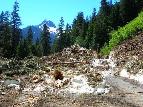
"I've got 10 km to go, going 10km/h - one hour. At 8 km to go, now going 8 km/h. Damn, that's still an hour! 5 km to go, 5 km/h..."

Eventually I saw Jennifer again, way ahead of me. I eventually caught up to her when she stopped, and kept moving, slowly, towards the top. Near the top I felt good, and the 10-foot snow-wall on the side of the road looked very fresh. There was snow on the side of the road almost all the way up, but this was lots and lots of it. Cool, I love riding near snow (just not ice).

At the top I was excited to start the descent, but again time was pressed. I had to be in Greenwater by 2:08 P.M., and it was about 12:30 by this point. I forget the exact numbers but I was in another situation where I needed to keep a 40 km/h pace from there to the next stop. The downhill was very fast, and of course went by quick. On the flatter section heading to Greenwater I wasn't sure if I'd make it in time.

Greenwater (497 km/309 mi) - I made it here at 2 PM sharp - only eight minutes to spare! I saw the Oregon Randos again, and a few more riders that were heading out. I felt like I was finally making contact with the rest of the riders again, and could catch up on time.

After Greenwater I headed out alone, cursing the cold shade of the trees but enjoying the fact that the passes were over with, and the rest of the ride should be much easier. I was starting to feel the sleep-deprivation effets, and even had a few instances of "did I just dream on my bike?"

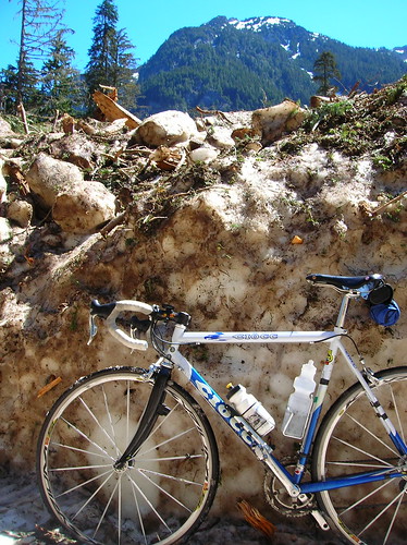
Then my problems started. Flat tire. No problem, although I had to chuckle since I was bragging to Chris the day before that I'd been flat-free for all of the brevets so far. This is on Highway 410, which has a foot-wide shoulder just small enough to ride on - but it's not a nice place to fix a flat. With a new tube installed, I go to use my pump. Hmm that's weird, it feels "sticky" and won't seem to work. After yanking on it a bit, all of a sudden I was holding two separate pieces in my hand - oh shit.

No cell phone, and I'm all alone. What to do? I tried my best to make the pump work again, but it was a lost cause. I knew Jennifer was behind me, and I figured she'd show up eventually. But there's wasn't anywhere to wait on this road so I just walked with the bike, heading towards Enumclaw. After 30+ minutes of just walking, a nice couple in a station wagon (w/ bike rack) pulled over and asked if I needed help. You bet I did!

Ironically, as we were pulling away I looked back to see Jennifer coming around the corner, so she probably could have saved my ride. But being in a warm car, off the bike, I'd given up in every way possible. My bike was already on the rack, and I decided I could do without finishing. A decision I regret, but oh well. Kyle & his wife, who's name I forget, were also riders and Kyle had done the RAMROD a few times, so he knew how crazy Cayuse Pass is. Thanks to them for stopping!

In Enumclaw I called Kira and asked for a ride - luckily she was home, and graciously came and got me. A while later we were packing the bike into her car and heading to Issaquah to get my drop-bag.

Even though I didn't complete the ride, it was still a great experience. I did a triple-century, something I never envisioned doing a year ago. I rested in a ditch, something I've wanted to try out. And a I learned that no matter how prepared you might think you are, something can still go wrong. Maybe I'll carry a backup pump from now on (I don't want to use Co2 cartridges, they seem wasteful to me personally). It's just ironic that I carry spare spokes, backup lights, a backup tire, spare cleat screws, a slew of tools, so I thought I had all the bases covered.

Physically I feel OK, although some finger-numbness is back. My legs are a bit sore, but not too bad. I might even go for a spin tonight just to see if I can. The only thing that's bothering me is the fact that I didn't finish the ride - but there will be many opportunities in the future to do something similar, and next time around I'll know more of what to expect, both from me (e.g. a tendency to sit around at controls) and my equipment.

Thanks to the ride organizers, and the volunteers too. I can't imagine doing these rides without their smiling faces!

Ride Stats:
Total Distance: 16 mi commute to start + 315 mi of brevet = 331 mi or 500+ km, my first triple-century!
Start time: 3 A.M. Saturday June 7th
End time: ~3 P.M. Sunday June 8th (36 hours overall, with 30 minutes of sleep)