Friday, April 25, 2008

(My) Seattle To Redmond Commute

I did the full commute to work in Redmond today, via I-90, Mercer Island, and Bellevue. 25 km each way, with small hills & a lake in between. I brought along a little digi camera and snapped some shots (mostly while rolling, can't be late). Enjoy!

(Click any image for its larger original size)

The view of downtown from my porch - yup, looks like a great day! Short sleeve (wool) jersey and arm-warmer kind of weather.

A few km into the trip, this is at Judkins Park in the Central District, on 20th Ave, heading south towards the I-90 trail. I've heard people say this is the "dangerous" part of town but I think that's ridiculous! I haven't had any issues commuting through here so far.

Just down the street from Judkins Park is a nice little view of the Sound - you can barely see it but it's there. I make a point to view (and enjoy) the water every time I roll past this intersection. I guess growing up in Key West means I love large bodies of water!
After the Mt. Baker tunnel, this is the view overlooking the I-90 floating bridge & the northern portion of Mercer Island (facing east). (There's a separated bike path from all that traffic, in case you're wondering)

Now on Mercer Island, this is looking back west towards Seattle. You can see downtown just over the hill there. That's more or less were I started the journey.

A few feet later on Mercer Island Way, briefly heading north. You can't really tell but his little kick can either propel me down it at 30-35 mph, or slow me down to 10 mph, depending if I'm going up or down it. It's really short but steep enough to make a difference. One day, I hope to sprint up it at 20 mph..


This is kind of in between Bellevue & Redmond, about 22 km into the ride. If you can't tell, this is atop a cliff I just pedaled up! This is 24th Ave, just off of 120th. Not long, but steeeep.

Then the camera ran out of batteries.

On the way in, I felt a little weak, probably due to lack of breakfast (just coffee). That was an average of about 25.5 km/h. Then on the way back, I really pushed my limits, and rode fast as I could. From Redmond to Bellevue (~5 km) and an average of 30.0 km/h! With those hills in between I'm pretty happy with that, but that's really not very far. By the time I was back in Seattle across the I-90 bridge (~18 km), the average was still 30.0 km/h! (18.6 mph). By the time I got home, it was down to 27.7 km/h. Woot.

Saturday, April 19, 2008

Extended Lake Wa Loop, Replete with Frozen Rain, Sleet, Hail, and Sunshine!

Just minutes before lift off, here I am getting ready to carefully descend four flights of stairs with a bike on my shoulder!


(I exaggerated the brightness on the pic above so you could see the jersey & bike better) Note that the bike is not your typical randonneur's bike, and in fact not the one I've been using on brevets. But if I can get used to it's racy fit, maybe I'll take it out on a brevet or two this summer.

Did a solo Lake Wa Loop today with a few detours, including breaking off of the Burke-Gilman trail to hit up the rolling hills that are 5th Ave through Seattle. As you can see, most of the big hills are at the end.

There was some rain/snow mix predicted, and when I rolled out at 12:15 P.M. from Capitol Hill it was a light mist of rain, nothing to worry about. No sign of snow, but I was actually hoping to see some and even ride in it.

So even though it was about 40F degrees & wet outside, my "armor" worked well: thick wool socks, booties, knickers, two short-sleeved jerseys, wool arm warmers. You know it's spring (well at least close) when you don't have to wear a jacket!

The wind was coming from the north, so holding 32+ km/h (20+ mph) wasn't too hard all the way down to Renton. At around Seward Park I chatted a bit with a guy also wearing a Seattle Rando jersey. Ty (sp?) was riding back to Dash Point from what I gathered.

Held a good pace through Bellevue, and when I got to the Kirkland area I drafted off a VW station wagon for a few kilometers at about 50 km/h (30 mph) on a flat stretch just before the Market Street climb. I wasn't even behind the car, just off to its right a bit, but still in their slipstream. That was fun!

The Market Street climb used to feel like quite the slog, but then again that was years ago and I was on a fixed gear then. Now it's pretty easy, just a warm up. Juanita is a more of a "climbers climb," and I held a good 25 km/h+ pace going up it. Passed up some other riders, trying not to seem like an asshole, but what can ya do? Some people ride faster than others, so why feel guilty? A little wave (lift of the fingers really) and I sped past them.

The downhill was fun, although at this point light slush was coming down. Held 60 km/h going down that for a good bit, man I love that downhill!

Then in Lake Forest Park I broke off the B-G trail and headed up into the city, on a windy uphill known as Perkins Way/185th St. Three miles long, but not steep until the end. The rollers through Seattle weren't bad either, but the rain was coming down harder at this point.

The hardest part was the climb back up Capitol Hill, up Harvard Ave off of Eastlake. Then 10th Ave, that's 10 or so blocks of straight climbing! Not the steepest, but tough on the legs after 4 hours of hauling ass.

Total Distance: 88.9 km (~55 mi)

Total Time: 3 hours 45 minutes

Rolling Time: 3 hours 25 minutes

Water/Food Stops: 0

Friday, April 18, 2008

Evening Spin To Queen Anne

Yesterday evening I set out to tackle Queen Anne's "Counterbalance" climb, which is about 400 feet over 8-10 blocks or so. [map]


It's mostly downhill from my house on Capitol Hill via Denny, and I can usually hold pace with or even beat the cars, but last night the traffic was mostly stopped, which slowed me way down at first.


By the time I got to Queen Anne, the light misty rain was turning into a light shower. No problem though: my wool jersey, wool arm warmers, full-fingered gloves, thick wool socks, lycra knickers, and body heat were more than enough to keep me warm. Not necessarily completely dry, but warm.


I love doing the Queen Anne climb, mostly because how steep parts of it are, but also because I never see any other cyclists doing it! So, yeah, I felt a little bad-ass slogging up it in my 39x23, in the rain, solo.


Towards the top (just before Highland Drive) the street pitches steeper, and my rear wheel started skidding! At one point there was an oil slick I could see in the road, and even though I went around it, my rear tire slid out three revolutions in a row! Who knows why I even held on, but I did, and pedaled out of the oil slick and crested the climb.


Went down the other side of the hill, then back up Queen Anne Ave heading south. Definitely not as steep, way less traffic, and gets less steep as you go up in that direction. But I like the harder route much more!


On the way back down towards downtown I stopped at Kerry Park for some postcard-quality views, and then slowly made my way back down the slippery pavement to the flats of lower-Queen Anne.


Hauled ass up Pine St, mostly in the big ring. Took Olive Way back up to Broadway, I love cresting the hill right there on broadway!


Distance: ~15 km
Time: ~45 minutes

Sunday, April 13, 2008

Boat Street Criterium (aka Brad Lewis Memorial Crit)

Another annual Seattle race, this one is in the U-district. I went down at about 10:30 this morning to see Rachael kick ass (again) in the cat 4 Women's race.

Also got some video this time!

Cat 4 Women:


Couple of notes from the race: Local cycling god (pro?) Kenny Williams was riding with the Cat 4 women's peloton, apparently coaching them in real-time! At first I was all, "who's that woman riding outside the peloton?" But upon a closer look you could see that it was Kenny, pedaling with a smile plastered on his face.

Also interesting to see some "discussions" in the breakaway about who was doing the most work - I heard a Wine's Of Washington rider yell to a Group Health rider (The break was two GH rides and the one Wines rider), "You can't just take the fucking downhill every time!" (Meaning, we've got to share the workload, and you're only taking the easy pulls)

But in the end, Group Health's strategy paid off, and they took the win. Nice work!

I've got a vid of the finish as well, need to get that up here soon..

Spectating at the Volunteer Park Crit

Yesterday a friend of mine was doing the Volunteer Park Criterium, which is always fun to watch! She was racing in the Cat 4 women's division, early in the day. I wanted to see the cat 5 men's division too, but got there too late.

I took the long way to Volunteer Park, which is about five blocks from my place. Up the hill to 15th Ave, John St down to Madison, then after a 60-70 km/h downhill, take a left on 28th Ave. I decided to hit up one of the steepest climbs around on the way to the race, just for fun. This is the Aloha climb that has one long section that's got to be at least 15-18%!

Doing that climb when fresh was a great feeling, I could actually keep a straight line and hold 10 km/h, as opposed to doing at 50 or 90 miles into a ride (then I'm pushing 5-6 km/h). It wasn't necessarily easy, but easier than usual.

Watching The Races

Rachael's already having a great 1st season, with top-10 finishes in all of her road races so far. So I knew she'd do well in this one too, her first crit. I could only hope for such a starting record.

She rode strong the whole time, in the front of the 50-woman peloton, sometimes even leading it! She ended up 6th overall, not bad for a first crit!! Congrats.

Writeups from racers: here and here.

Riding after the races

John, Andy & I did the southern portion of the Lake Wa Loop after watching the races. It was a perfect day for it: 70+ degrees & sunny! I even had to take off my arm-warmers. That's the kind of weather I've been dreaming out for the last six months or so..

We did the counter-clockwise loop through Leschi, Renton, Bellevue & Mercer Island. On the I-90 bridge heading back to Seattle I was holding 50 km/h (30 mph) at first, and kept it above 45 km/h the whole time, somehow it felt almost easy! A tail wind perhaps? The light & stiff Ciocc definitely helps..

I was trying to catch a racer in The Garage's racing kit, who started out way ahead. I didn't realize it at the time, but John said that a Cucina Frecsa racer was drafting me the whole time. Once I hit the incline leading up to the Mt. Baker tunnel, I could no longer hold 45-50 km/h, but stood up and kept a 32 km/h (20 mph) pace. I don't usually go that fast uphill, but it felt like I was being propelled, by my own momentum, and also by the motivation of watching races earlier. John said I dropped the Cucina guy going up the incline too. Not that it counts for anything.. but it was fun.

Monday, April 7, 2008

I Won The Lottery!

No, not the one that curses you with too much dough and makes everyone come out of the woodwork to help share the winnings..

I won a lottery that will result in me draining the energy out of my body at a rapid rate, and hopefully replenishing at nearly the same rate. (Which is harder than it sounds!)

But I wasn't the only one that "won" this lottery. 799 other people got picked to take part in the annual Ride Around Mt. Ranier In A Day, aka the RAMROD!!

If you didn't enter or didn't win the lottery, don't dispair! Sounds like they'll be auctioning off a few tickets on ebay, but I wouldn't be surprised if that gets a bit out of hand.

The quote about the ride:

RAMROD [Ride Around Mount Rainier in One Day] is the Pacific Northwest's premiere one-day ultra-marathon cycling event. It combines the incomparable scenery of Mount Rainier National Park with a challenging course featuring 10,000 feet of climbing over 154 miles. The course starts in Enumclaw, WA (elevation 720 feet) with a gradual downhill to its lowest elevation (300 feet) near Orting. This is followed by 40 miles of rolling hills through the towns of Eatonville, Elbe, and Ashford, with a gradual climb to the Nisqually entrance of Mount Rainier National Park. The climb stiffens at Longmire where riders begin the 12 mile ascent to Paradise (elevation 5,420 feet). A 12-mile descent through Stevens Canyon follows and then a quick 3-mile climb to Backbone Ridge. This leads to one of the most fun descents of the course: a swooping 5-mile run to the Grove of the Patriarchs and the intersection with Hwy 410. What follows is generally considered the most difficult section of the course: the 9-mile climb up Cayuse Pass (elevation 4,694) which starts at 100 miles into the ride. The rapid descent from the pass ends with about 30miles to go. These last miles are gradually descending or rolling except for one final, fast descent down Mud Mountain Dam just 5 miles from the finish in Enumclaw. Join us for the 25th anniversary of RAMROD – it will be the best RAMROD ever.

Oddly enough, this ride won't be the apex of my riding season, that will most likely either be the 400k brevet (Snoqualmie, Blewitt, Stevens Passes in one day!) or the 600k, or the CANNONBALL/S2S if I do those.

But even though this will be a "training" ride for me, that doesn't mean it'll be easy!!

Sunday, April 6, 2008

SiR 300k Brevet: Lacey-Vader-Chehalis-Lacey (and a lot of hills in between)

Finally, a brevet that counts! After the last one, I was set to finish a brevet officially, within time, and get credit. Well I did! And it took about 20 hours to do it too. Yeah, 20 hours on the road! Not necessarily always on the bike, but out in the open, and doing something that was getting us closer to finishing the ride, whether that was pedaling, fueling up, or fixing a mechanical issue.

While this ride was about 20 miles shorter than the 200-mile STP, it was definitely harder to say the least. Not only was there at least twice as much climbing, but the (cold) weather was also a factor in this.

The Ride To Robert's House
Robert was kind enough to offer me a ride to the brevet, starting 50 or so miles away in Lacey, near Olympia. So I got up at 3:30 A.M., got ready, and pedaled down to his house about 10 miles away.


Here's my Miyata before liftoff at 4:30 A.M. Two filled water bottles, Carradice bag full of (a big bag of) tools, pump, two extra sets of gloves, extra glove liners, extra arm warmers, some leg warmers, my rain jacket. (The camera must've been on manual mode, because the picture exposed too long and that's why the image is all shaky)


Riding through downton, heading towards Alaska Way (photo looking north). I wish SiR would do some brevets in and around the city, but oh well. There's something to be said for country riding, but with the distances we cover we could easily do both!

The Brevet

Here's a map of the first 200km of the ride. The terrain map shows the hills we encountered along the way: [map 1/3] (Lacey to Chehalis) [map 2/3] (Chehalis to Rainier) (I couldn't figure out the rest of the route based on the cue, as the Google Map didn't show the bike trails we went on)

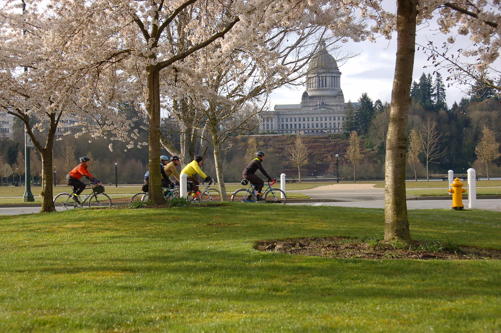
The peloton rolled out at a La Quinta in Lacey, just east of Olympia at 7 A.M. sharp. We headed north, towards Johnson(?) Point to the north, and then looped back to Olympia. Here's a shot of the capitol building there:


Here's a great shot of me & the rest of our crew (taken by the SiR photographer, thanks!).

I have no idea where this was, but you can see how rough the pavement was, probably chip-seal. We had no idea how sour the weather would soon turn.. or maybe it was just a break in the rain, can't remember.
Not sure where this was, but it was most likely before 2 P.M. because the rain hadn't started yet. In the distance, you can see a little sample of the oodles of rolling hills we conquered.

The hardest part of the whole ride was the open flats leading to Vader (not even the 10% climb leading to Vader). All four of us were pacelining, battling the wind, rain, fatigue, and on the verge if not bonking. Taking mile-long pulls each, we slogged through it at 20-21 km/h (12.4 mph). We each admitted later that we were privately thinking of calling it a day at the next control; luckily none of us did! Had I been riding solo I probably would've taken a shortcut back to Lacey at this point, or something, as I was seriously on the edge of giving up.

The Diner in Vader

Even though I had a handlebar bag full of granola & candy bars, I felt hungry but just couldn't eat that stuff anymore. In Vader at about 6 P.M., we stopped at a tiny diner next to the control, and sat down for some "real food." We'd been pedaling in the cold rain for hours, and the space-heater in the small diner was just too good to be true.


We were quite the spectacle for the locals, that was pretty funny. I forget their choice quotes, but they were surprised, to say the least, that we started and were heading back to Lacey! Guess they don't get many city-slickers dressed in spandex & wool this time of year..

After eating we rolled out again at about 7 P.M., and the rain had lightened up a bit.


The Rest of The Ride

After some real food, we all felt at least 90% better, and were ready to finish this damn thing. The next section to Chehalis was isolated country roads, with more rolling hills to tackle. When the darkness kicked in, our lights lit up the road excellently, and we quite a few deer on the side of the road. Not too many cars out in this area, it was pretty calm. I wish it had been light still at that point, as the views were probably nice, but I'm sure I'll get another chance to do this route.

Other Tidbits
  • The control in Porter had some great french-fries, and felt like a true "country store." Part of what helped that was the pictures of gleaming teenagers holding the bloody & severed head of a deer. Or the picture of a smiling family standing next to a big deer's body hanging from a tree, and the deer's head sitting in a different spot in the yard. I hope they at least at those poor animals!
  • When we finally got to the control in Chehalis, the worker at the Main Street Food Stop (?) initially had no idea what we were talking about when we displayed our brevet cards! But the card even said the store's name on it, so we finally convinced her to initial & write down the time on it. She wished us well on the way out, and reminded us to look out for drunk drivers.
  • It seemed like we were constantly passing the same riders over and over again. One rider eventually nick-named us the "fantastic four," and by the time we showed up at the final control everyone seemed to have been informed of this. Works for me!
  • There were a few packed-gravel sections due to the floods that happened last year, and luckily my 23c front & 25c rear tires held up just fine. The sections were maybe 100 feet in length, so nothing too bad. Closer to the end of the ride, we had to go through mud for about 50 feet, but that was a scary section! My front and rear tires were fish-tailing, and it was all I could do was to stay upright. The last thing I needed at this point was to go down in a mud puddle! I'm guessing they did the pre-ride & route planning when it was dry, but maybe SiR likes to toss you on crazy sections like that just to test you.
Thanks to Robert, Joby, and Chris for riding with me, it was a great ride! We are indeed the fastastic four. And I'm sooo glad we didn't quit. Now it's get ready for the insane three-mountain-pass 400k!


Total Distance: 300km + 20 km to get there + 5 km of getting lost, turning around = 325 km (202 miles)
Elevation: ~7,500 feet. Here's the elevation profile for just the first 200k of the ride - max elevation of ~925 feet. If I'd looked at this again before the ride, maybe I wouldn't have been surprised by all the tough climbing we had to do.

Some great photos taken by an official SiR photographer - and we're in some of the photos. Worth checking out: link.